
A Photo Journal by Betty Wheeler
Jump to: Day 1 | Day 2 | Day 3 | Day 4 | Day 5 | Day 6 & 7 | Day 8 | Day 9 | GEAR LIST
Hiking the High Sierra from Yosemite to Mt. Whitney on the famed John Muir Trail: what better way to celebrate birthdays (my 59th and Laurie’s 64th) and the 50th anniversary of the Wilderness Act?
Planning this popular trek begins 168 days in advance of the first step, playing the “fax lottery” to attempt to win a permit reservation. Demand is much higher than supply, especially since JMT hikers compete with Half Dome and Cloud’s Rest hikers for permits for Yosemite Valley’s Happy Isle trailhead, the start of the John Muir Trail. We secured an alternate starting trailhead, Glacier Point, 3200 ft. above Yosemite Valley, which gave us a slightly longer (+1.7 mi.) route to the first night’s stop required by our permit (Little Yosemite Valley), but also gave us this dramatic beginning point (click on photos to see larger versions):

Laurie and Betty (l-r), at Glacier Point on Aug. 13, ready to hit the trail for our 22-day hike. Laurie is playing air fiddle with her trekking poles; check out her real music here.
Day 1: Glacier Point to Little Yosemite Valley
August 13
6.2 miles
JMT end point: Mile 4.5
Starting elevation: 7,214 ft.
Ending elevation: 6,130 ft.
Note: We used Elizabeth Wenk’s book, Richard Strimbeck’s Excel-based JMT SOBO Profile Planner, High Sierra Attitude’s John Muir Trail Hiker phone app (formerly known as “Guthook’s Guide: JMT”), and Tom Harrison’s printed JMT Maps as our data sources; there are often slight variations in mileages and other data among these sources.
The clear beautiful weather that greeted us at Glacier Point was no fluke. On our 22-day trek, we had nearly perfect weather – one day was cloudy and windy, but we saw not one drop of rain. Hikers just a couple of weeks ahead of us had been driven off-trail by monsoonal storms featuring thunder, rain, hail and snow – so we were definitely blessed by the weather gods. Our hike was also unmarred by smoke, a huge issue for last year’s August hikers, and also for some of this year’s hikers, due to 2014 fires such as El Portal and Dark Hole.

Illilouette Fall, a 370-foot waterfall on Illilouette Creek, a tributary of the Merced River.
Hiking from Glacier Point took us along the splendid Panorama Trail past Illilouette Fall, a 370-ft. waterfall in a small side canyon across from Vernal Falls. While JMT’ers starting at Happy Isle begin at 4,040 elevation and must ascend to 6,020 ft. in the first 2.8 miles, we enjoyed a gradual descent from 7,214 to 6,020 ft., where we joined the John Muir Trail at Mile 2.8 of the JMT, just 0.5 mi. before reaching the top of Nevada Fall. This kinder, gentler start (and the dramatic views) were well worth the slightly longer mileage for the day, especially since our permit required us to stop at Little Yosemite Valley.
Along the way, we encountered a large rattlesnake that rattled at Laurie in a desultory way as it left the trail for the nearby manzanitas. My photos aren’t very clear, and only hint at the very large size of this snake, but you can (barely) discern the rattles in the 2nd image:

We soon reached the top of Nevada Fall, with its usual large crowd of visitors and its spectacular views.

The top of Nevada Fall, approx. 6000 ft. elevation.

View of Yosemite from the top of Nevada Fall.
Little Yosemite Valley is a large backpackers’ campground, but we found a relatively secluded spot for the night under tall trees, not far from the lovely Merced River, where we enjoyed a quick dip to freshen up and the opportunity to top off our drinking water supply.

The Merced River, by our Little Yosemite Valley campsite.
Day 2: Little Yosemite Valley to the Sunrise High Sierra camp
August 14
8.7 miles
JMT Mile 4.5 to Mile 13.2
Total up: 3742 ft. | Total down: 321 ft. | Net elevation gain: 3180 ft.
Camp elevation: 9310
The hiking crowd on the trail today thinned considerably after many people left the JMT at the Half Dome and Clouds Rest trail junctions. Laurie had previously climbed Half Dome twice, so we bypassed that side trip and continued on the JMT as it followed Sunrise Creek, enjoying a beautiful view of Mt. Clark.

Mount Clark (11,527 ft), named for Galen Clark, an early explorer and the first guardian of Yosemite National Park.
We began a big climb up Sunrise Mountain, and then finished with a short descent to Long Meadow and the junction to the Sunrise High Sierra camping area.

Laurie on the trail through Long Meadow.
At the backpackers’ camping area adjacent to the Sunrise High Sierra Camp, we shared a site and trail stories with a young man from Japan who was solo-hiking northbound, and was nearing the end of his trek. Our site was high above the pen holding the mules who carry food and provisions for those staying at the Camp.
My day was marred by something completely unexpected: altitude-induced nausea, which I’d never experienced at such low elevation. I’m pretty sure it was my payback for saying I don’t have altitude issues below 13,500 ft., based on my previous experiences on Mt. Whitney and Southern California’s high peaks (San Gorgonio, San Jacinto, Mt. Baldy). A round of Diamox resolved this once we reached Mammoth on Day 6, and it wasn’t enough to mar the beauty of our ever-changing surroundings, but I did find myself dragging along the trail for several days until I had a chance to get the drug. Lesson learned – Diamox will always be in my emergency kit from now on!
Day 3: Sunrise High Sierra camp to Tuolumne Meadows
August 15
9.8 miles
JMT Mile 13.2 to Mile 23.0
Total up: 1437 ft. | Total down: 2307 ft. | Net elevation gain: -725 ft.
Camp elevation: 8585
Today’s plan included our first mountain pass, crossing the Cathedral Range at Cathedral Pass (9700 ft.) before dropping into Tuolumne Meadows. There, we would pick up our first resupply, a box of provisions I mailed to the Tuolumne Meadows Post Office before our hike began. Our plan was to get through part of Lyell Canyon if possible, with a fallback plan of staying at the Tuolumne Meadows backpackers’ campground, since there is a four-mile no-camping area in the first part of Lyell Canyon. Given my altitude sickness, the fallback plan was the order of the day.
The climb toward Cathedral Pass is through an open lodgepole forest with stellar views of the Cathedral Range, including Matthes Crest, the Echo Peaks, Cathedral Peak (first climbed by John Muir, in 1869), Columbia Finger and Tresidder Peak. A shallow cirque cradles the Upper Cathedral Lake, surrounded by the lower walls of Tressider Peak and the Echo Peaks.


We descended through lodgepole and hemlock forest, past the divide between the Merced and Tuolumne River drainages, to Tuolumne Meadows, complete with Grill (a drink with ice! lunch featuring food that has never been dehydrated!), the tiny Post Office where we picked up our resupply and re-packed our bear can, and the $5 backpacker’s campground, where we enjoyed visits with our neighboring hikers and a campfire program featuring “mountain songs and tales” by a terrific ranger. Her stories about her grandmother’s trips to Yosemite in the early part of the 20th century were priceless.
Day 4: Tuolumne Meadows to 1.7 mi. past Donahue Pass
August 16
14.8 miles
JMT Mile 23.0 to Mile 37.8
Total up: 3063 ft. | Total down: 1301 ft. | Net elevation gain: 1785 ft.
Camp elevation: 10,370
A long and beautiful day took us through magical Lyell Canyon, with the Lyell Fork meandering through, offering many opportunities to get drinking water (what a luxury, to carry only a half-liter!), soak one’s feet, and see the most amazing water displays, with ever-changing colors and aspects.


We also shared the meadow with a coyote:


The climb out of Lyell Canyon was similarly beautiful, with frequent water, lodgepoles followed by mountain hemlock stands, a timberline meadow and whitebark pine, views of Mt. Lyell, and a snowfield that Wenk says was once the largest glacier visible from the JMT, but was redesignated in 2013 as a “permanent snowfield,” meaning it no longer has enough mass to move downhill.


Donahue Pass itself featured a lovely tarn, and at 11,060 ft., we considered it quite an accomplishment, though a northbounder told us it was “a good warmup pass” for what is to come. The pass is the boundary between Yosemite National Park and Ansel Adams Wilderness, and from here, according to Wenk, “the 5.1-mile leg to the top of Island Pass is the only section of the JMT that is east of the Sierra Crest,” not including the descent from Mt. Whitney, where the JMT ends.
Day 5: Past Donahue Pass to Rosalie Lake
August 17
12.5 miles
JMT Mile 37.8 (1.7 miles past Donahue Pass) to Mile 50.1
Total up: 2437 ft. | Total down: 3455 ft. | Net elevation gain: -1020 ft.
Camp elevation: 9,350
Beautiful sights today, along with a misstep that made it one of our hardest days as well.

A morning view of the beautiful water and rock-slab feature by last night’s camp, about 1.7 miles past Donahue Pass.


Mid morning, we encountered young parents camping with a 10-month-old baby. It looked daunting: they had four bear cans, a huge pot and cook kit, and mom had a baby carrier on her pack. Wow, think about packing out all those dirty diapers! We expressed our admiration for their endeavor, then hiked on to a beautiful lunch spot on the shore of Thousand Island Lake.

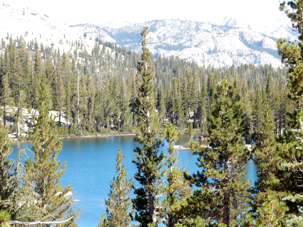
Thousand Island Lake, dotted with many rocky islets and with the dark Ritter Range as its backdrop, including Banner Peak.

A post-lunch wade – the cold water is so therapeutic for sore feet!
The trail took us near beautiful Emerald Lake:

Emerald Lake – look closely and you’ll see someone on the rock that juts into the lake.
Right afterwards, we were at Ruby Lake, and here, we couldn’t resist jumping in for a very brisk and very quick swim. (Laurie may have a photo of me actually in the lake: if so, I’ll post it later. For me, it was my only “full immersion” experience on the trail, though Laurie braved the cold waters more often.)

Ruby Lake: the site of my only “full immersion” experience on the JMT, though I waded knee-deep in other lakes. You can tell that snow melt is the source of these beautiful but cold lakes.
After we left Ruby Lake, Laurie hiked ahead of me, and became engrossed in conversation with a fellow hiker as they neared Garnet Lake. She followed him down a use trail to lake campsites, on his assurance that it was the trail. Meanwhile, I hiked the trail ever faster, trying to catch up with her, at one point hearing from a hiker coming from the other direction that she was 15 minutes ahead of me. In fact, she was behind me, since she had to backtrack from the use trail back up to the JMT. She hiked hard trying to catch me. As a result, we both hiked harder than we ordinarily would have, trying to catch up with the other. Lesson learned: if you and your hiking partner are not hiking together, wait at any trail junction for the slower hiker.

These two photos show most of Garnet Lake – the trail briefly traces its north shore, crosses its outlet on a footbridge, then goes upward along its south shore before climbing steeply up the ridge to the south of the lake.
We camped for the night at Rosalie Lake. At 1:42 am, I woke up to the sound of two hikers who were almost running the trail by headlamp, trekking poles clacking. I could only imagine their story, but it didn’t look like much fun.

Our camp for the night was at Rosalie Lake – my photo notes are sketchy, but based on the time, I’m pretty sure this is Rosalie Lake, though we also passed Shadow Lake on the way.
Day 6 & 7: Rosalie Lake to Red’s Meadow & Mammoth /plus a Zero Day in Mammoth
August 18
9.1 miles
JMT Mile 50.1 to Mile 59.2
Total up: 1013 ft. | Total down: 2645 ft. | Net elevation gain: -1630 ft.
August 19: a “zero” day
Today, we got an early start (6:40 am), eager to get to Red’s Meadow, where Dwight and Tom would be picking us up and driving us in to Mammoth Lakes for resupply and an overnight respite, including such fabulous things as shower, laundry, iced drinks, and non-trail food. Our plan was to arrive at approx. 11:00 am and we arrived at 10:58 am, to find Dwight and our dog Molly, and Laurie’s partner Tom, waiting for her with a Haagen-Daz ice cream bar in hand.
With the lure of Mammoth foremost in my mind, I have only two photos to show for our morning’s hike: a lovely photo (taken at 6:44 am) close to last night’s campsite, and a photo showing the geological formation known as Devil’s Postpile in the distance, with someone standing on top, where you can see the polished hexagonal tops of the columns, with the twisted columns visible below.


Devil’s Postpile, as seen from the JMT.
Mammoth was my chance to get Diamox, and to have a very helpful phone consult with doc friend Harvey Shapiro about my altitude sickness. It took awhile for Dwight and me to contact our doctors and get prescriptions phoned in to the Mammoth pharmacy. We also had a hilarious mishap in that Dwight, who was charged with bringing the resupply boxes I had prepared in advance so that we could re-stock our food and other supplies, brought the wrong box. So Dwight and I ran around Mammoth Lakes, which luckily has a decent grocery story, a small but excellent natural foods store, and a well-stocked mountaineering shop, which allowed us to get almost everything that was in the resupply box that never left home.
Given my days of altitude-induced nausea, our day of hard hiking in the Garnet Lake section, and the need to run around replicating the missing resupply box, I talked Laurie into staying an extra night so that we could go back on the trail really rested and refreshed. So we had our first and only true “zero” on the JMT – a day with absolutely no hiking. I totally loved it, and at least for me, it was worth having to add a couple of extra miles to the following few days to get back on schedule.
Day 8: Red’s Meadow to Purple Lake
August 20
13.2 miles
JMT Mile 59.2 to Mile 72.4
Total up: 3740 ft. | Total down: 1460 ft. | Net elevation gain: 2250 ft.
Camp elevation: 9970 ft.
Dwight drove us back to Red’s Meadow, and dropped us off at the very closest point possible to the trail, which was right by the Red’s Meadow Packing Station. Here are Dwight’s photos of us, clean and rested, and hitting the trail:


The Devil’s Postpile area is significantly marked by two natural events: a powerful windstorm on November 30, 2011 that toppled more than 10,000 trees between Yosemite and Tully Hole (“the Devils Windstorm”), and a large, lightning-caused fire in 1992 (the Rainbow Fire).

The most recent volcanic event in the Devil’s Postpile area created the Red Cones:

The Red Cones are basalt cinder cones, with well-preserved summit craters, created in the most recent volcanic event in the area.

During the day’s hike, we crossed Crater Creek several times, with wildflowers along its stream banks, crossed a saddle marking the boundary bertween the main Middle Fork of the San Joaquin drainage and Fish Creek, forded Deer Creek, and began a steep switchbacking climb past the Duck Lake trail junction at 10,150 ft. elevation, and on to the lovely (but cold) Purple Lake, where we camped for the night.


Day 9: Purple Lake to a meadow 2.7 miles beyond Silver Pass
August 20
11.9 miles
JMT Mile 72.4 to Mile 84.3
Total up: 2602 ft. | Total down: 3633 ft. | Net elevation gain: -990 ft.
Camp elevation: 9640 ft.
Purple Lake was beautiful, earning its name during short moments around sunset and sunrise, but very cold. A hard morning to get out of the sleeping bag!

My Purple Lake photo does no justice to this beautiful spot. I’m hoping Laurie can provide a better one to replace this one, but I want to remember this mystical place and its sometimes-purplish color.
A beautiful hike awaited us, especially along the Fish Creek headwaters and Tully’s Hole, usually mosquito-ridden but not on the day we were there. Beautiful rushing water, deep swimming holes, wildflowers and no mosquitoes! Some scenes from the day, starting with what I believe is Lake Virginia:


Laurie on the final stretch of trail before reaching Silver Pass.

This is probably Squaw Lake (elevation 10,290) – definitely one of the beautiful lakes & tarns just before Silver Pass


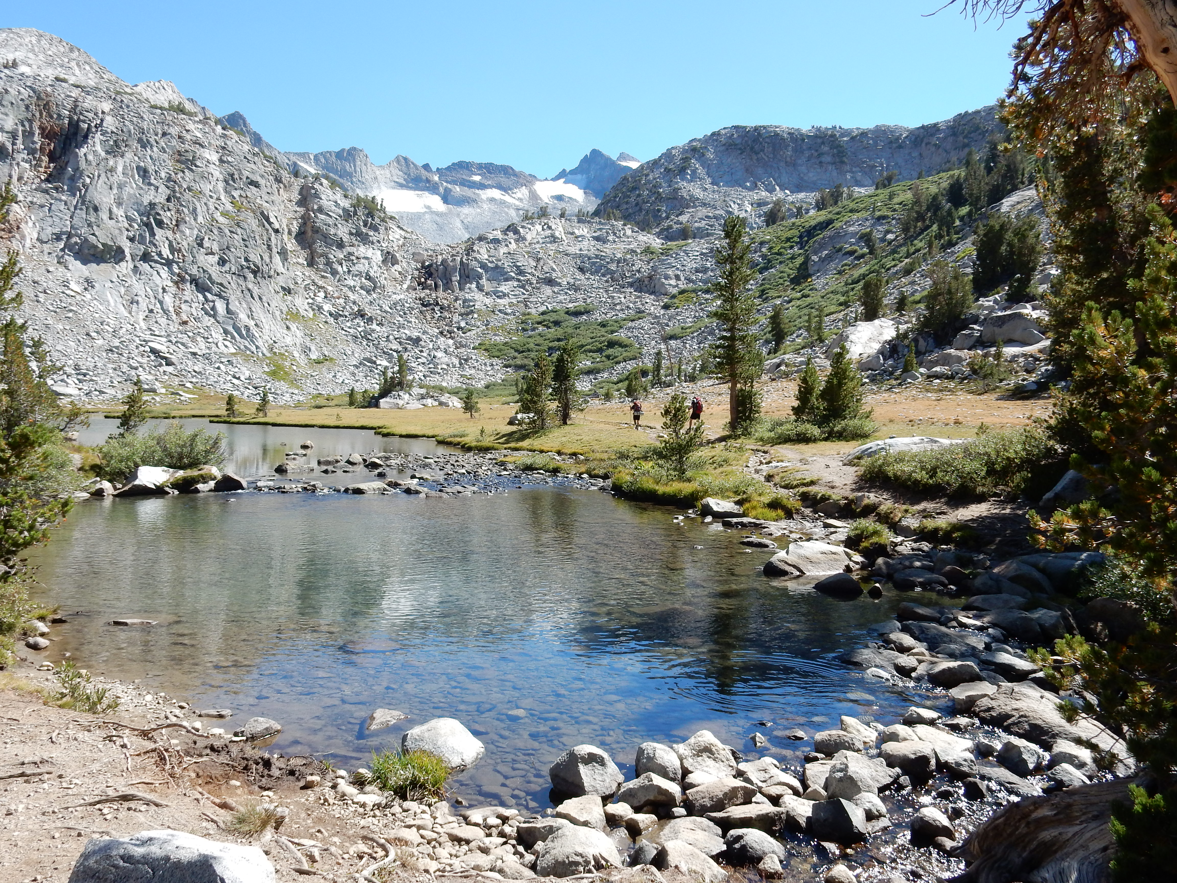
As we hiked upward toward Silver Pass, we passed first through hemlock and lodgepole forests, crossing the creek twice, with the landscape becoming thinner, with stunted trees, subalpine vegetation, small alpine meadows, and then exposed spaces and tarns. As we drew close to Silver Pass, we could see people congregated on the pass, and we hiked up to join the festive celebration of the pass, and then went down a way to a camp by a gorgeous rock slab water feature. Some photos from this part of the day:


On Silver Pass (elevation 10,740); behind us is a glimpse of what we hiked through today to get here.
A few photos looking in the direction we just came from, and showing much of what we hiked through today:


…and a photo looking down toward the next stretch of our hike, which ended approx. 2.7 miles beyond Silver Pass in a beautiful meadow:

[COMING IN THE NEXT FEW DAYS: DAY 10 – DAY 22]

Adorable and lovely in every way!
LikeLike
Thanks for your kind comment, Cindy – greatly appreciated!
LikeLike
I am in absolute awe at what you two accomplished! Just wonderful!! And thanks for the fabulous travel log and pictures so we less able/motivated could enjoy!
LikeLike
Lynn, you should have seen how Molly looked at me and my pack when I saw her at resupply points. She’s a smart enough dog to know I was out there hiking without her… But she got to go fly-fishing with Dwight, so she had some fun, too.
LikeLike
Bravo, be the first to actually bring a violin next time . . . I’ve see a variety of guitars, ukelele’s and things that look like sticks with strings . . . and yeah, never hard to find that energy for the last few miles.
LikeLike
Bob, I’ve seen Laurie take a violin on a river trip – but don’t think she would be willing to add even a few ounces to her pack weight. She did sing sometimes along the trail, and wrote a pretty cool pika song. As for finding energy for the last few miles — last year, when I did Whitney from the Portal and back, I was more than happy to crawl into my tent at Consultation Lake before descending all the way. But this year, by Day 22, I felt like Superwoman!
LikeLike
Thank you for documenting and sharing your trip. I am soaking in the details…imagining the day when I can do the same trail.
LikeLiked by 1 person
What a fantastic trek and wonderful pictures to make the rest of us envious! I am in complete awe at your accomplishment. Congratulations!
LikeLiked by 1 person
You two are super women! Thank you SO MUCH for sharing these fantastic pics and your journal. Congratulations on accomplishing this unforgettable journey!
LikeLiked by 1 person
Thanks, Claire! We shared the trail with a terrific 68-year-old woman from Alabama – hoping to hear from her and get some of your music to her. She has a banjo and dobro she wants to learn to play!
LikeLike
Spectacular in every way!
LikeLiked by 1 person
I’m mightily impressed, and envious. What beauty! Scenery’s splendid, too.
LikeLiked by 1 person
Wow – You guys are bad-ass!! Congrats!! So glad you had such perfect conditions for this ambitious endeavor.
LikeLike
Mark – thanks for the “bad-ass” recognition! As for the conditions, I’m watching the photos of the fire near Half Dome that is going on now — wow, we were SO lucky to have missed that.
LikeLike
Wow! What a fantastic adventure – thanks for sharing, Betty. I’m looking forward to the next chapter.
LikeLiked by 1 person
Simply incredible. Thanks for sharing!
LikeLiked by 1 person
Wow! Great pics! I’m both jealous and inspired… Congrats to you both on putting this fantastic trip together!
LikeLiked by 1 person
Hey, Betty, I love reading your account of our adventure. It was a great one! Your photos bring back such a barrage of memories. My blog (only on Day 2 as of now) is at highsierrarambles.wordpress.com, if anyone wants “the other side of the story.”
LikeLiked by 1 person
Thanks for the link, Laurie. Will “the other side of the story” include the knife fight, the cougar attack, and your photo series of wild animals pooping??? Seriously, thanks for being such a great hiking partner!
LikeLike
Wow! How impressive is this! Wonderful photos and narrative…waiting for the next installment!
LikeLiked by 1 person
Laurie and Betty. After having a family summer cabin in the Sierra just north of Yosemite since 1955 in what is the Sonora Vacation Land area of Pinecrest, these pictures still bring an awesomeness and newness to the Sierra I have come to know. You have visited lakes I have only seen by a huge Sierra map on our cabin wall. I can’t wait to see the remaining leg south. Thanks for letting us in to your time. Hard for me to imagine Laurie being away from the fiddle that long.
Regards
LikeLiked by 1 person
Great Blog and Photos! We love it!
Best regards from Baden-Württemberg, Germany
LikeLiked by 1 person
Spectacular and inspiring. I hope when I take on the JMT, I have as much stamina as Laurie and you – and, of course, the weather.
Wayne Brechtel
LikeLiked by 1 person
Wayne – As a PCT section hiker, you’ll have the luxury of choosing a better window than the thru-hikers — I sure wouldn’t want to do the high passes when they’re snow-covered! But getting our weather? Chances of that are slim. I saw a photo from Aug. 12 (the day before we started) of a big group huddled in the Crabtree Ranger Station, sheltering from a big thunderstorm, and of course, right after we left the trail, the Meadow Fire blew up and closed part of the trail in the LYV-Sunrise area. We were so lucky!
LikeLike
Thank you for sharing. What fantastic, awe-inspiring, very serene photos. And what an impressive effort. You ladies are amazing. You have inspired me to make sure I can join my dad when his trail hiking reaches the JMT. It looks like a trek not to be missed, even if we can’t quite replicate your perfect weather. Looking forward to the next installment.
LikeLike
Betty
I finally had a chance to sit down, relax and read this. I really enjoyed your travel descriptions and your photos. Good job on both! Congratulations on achieving your goal in such fine style! Felicia
LikeLike